Odyssey image
For Scientists and Researchers
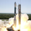
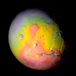
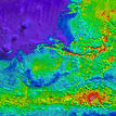
The Thermal Emission Imaging System (THEMIS) is an instrument on board the 2001 Mars Odyssey spacecraft. It combines a 5-band visual imaging system with a 10-band infrared imaging system.
THEMIS began scientific mapping February 18th, 2002. Below are links to all released data, instrument descriptions, useful software, and THEMIS-based publications in refereed journals.
---
Map of All THEMIS Images A web map that lets you find THEMIS images of Mars by pointing and clicking. Geology Cover featuring THEMISOdyssey looking down for water
THEMIS Data Releases Provides access to all publicly released THEMIS data.
Maps of Mars Images Maps of Mars with the footprints of all images taken by THEMIS and MOC, with more on the way.
Global Data Sets Access to scientific data sets that cover all of Mars.
Process THEMIS Data (THMPROC) A web-based interface for processing THEMIS infrared data.
JMars A geographical information system that provides easy access to many different Mars data sets.
Davinci A programming tool to manipulate and view multispectral data.
Spectral Library A library containing thermal emission spectra of a variety of geologic materials.
Software and Tools Available research software used by THEMIS scientists and researchers
Landing Site Support THEMIS is helping the Mars Science Laboratory team select a safe but interesting landing site for the MSL rover.
Projects List of active projects the Mars Space Flight Facility is currently working on.
THEMIS Instrument Basics A short description of THEMIS, plus links to more technical information.
THEMIS Documentation Technical documents and user guides for THEMIS data.
THEMIS Publications A list of THEMIS publications in refereed journals