Into the Highlands
On the southwest edge of the immense volcanic region of Tharsis, lava from its giant volcanoes flowed down to meet the old cratered landscape of Terra Sirenum. Scientists can't say how many years separate the flows from the terrain they engulfed, but the relationship between the two tells of a complex tale.
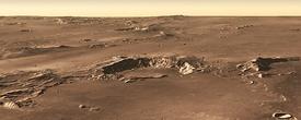
This false-color mosaic image combines separate frames taken by the Thermal Emission Imaging System (THEMIS), a special camera on NASA's Mars Odyssey orbiter. THEMIS photographs Mars in 10 infrared "colors" and five visible ones.
The infrared imaging gives scientists clues about the nature of the surface. THEMIS photographs patches of ground twice per Martian day - once in late afternoon and then again just before night ends - two times when contrasts in surface temperature are strongest.
Under full sunlight, dust, sand, and loose sediments grow warm, even hot, as anybody knows who has walked barefoot across a sunny beach. (Dark materials also do the same.) In the depths of night on Mars, however, fine particles quickly become cold as temperatures plunge after sundown. But rocky areas and ones with expanses of compacted sediments hold onto heat better and glow warmly in THEMIS' infrared vision.
In this false-color mosaic, THEMIS researchers have colored in blues and greens the areas that are cold at night, while nighttime-warm regions appear in reds, oranges, and yellows. The tints distinguish areas covered in dust and sand (cool colors) from exposures of bare rocks and deposits free of fine-grain material (warm colors).

Flood
The close-up image at left shows a geological story with at least three episodes. The oldest appears in the buckled terrain at the bottom of the frame.
This sculptured slope is part of the outside wall of an impact crater 43 kilometers (27 miles) wide. The crater formed early in the oldest period of Martian history, the Noachian, which lasted from the planet's formation (4.6 billion years ago) until about 3.8 billion years ago.
Since the impact, the crater rim materials have accumulated a coating of fine-grain debris. This causes the ground to appear blue in the false-color image because the materials are cold by the time THEMIS passes overhead late at night.
Some time after the meteorite strike that made the crater, lava flows buried the rumpled blanket of ejected debris that originally surrounded the crater, erasing it right up to the foot of the crater-rim. This flow appears in the center of the frame as a flat surface tinted blue, thanks to its dusty covering. It lies sandwiched between lobes of younger, rockier lava flows tinted yellow and orange.
The younger flows mark the third geological episode. They are about 40 meters (130 feet) thick as seen here, but thicknesses vary across the region. It's easy to trace the youngest flows, which lack a covering of cold dust and sand.
Both episodes of lava flooding, old and new, form part of the vast Daedalia Planum region, a huge lava sheet made of countless individual streams and flows. Daedalia spreads south from Arsia Mons, the southernmost of the giant volcanoes of Tharsis.
Scientists think Tharsis began to build in the late Noachian and continued to develop in the Hesperian, the middle period of Martian history. This spanned between roughly 3.8 and 3.0 billion years ago. Finally, the great volcanoes themselves culminated in the Amazonian, the current Martian geological period.

Stretch
Lava sheets are broad, thin, and brittle. The floor of the channel here lies about 50 m (160 ft) below the surface of the flow, and forms what geologists call a graben (grah-ben). It spreads about 2 km (1.2 mi) wide here.
This graben isn't the only one in the area. A look at the big mosaic shows traces of other grabens, all trending in a southwest-northeast direction. And looking even farther afield, scientists note more grabens with much the same directional trend where the Terra Sirenum highlands descend to meet the lava flows of Daedalia.
What's going on? The grabens are not aligned by chance; instead, they reflect geological stresses at work across the whole Daedalia region. And the driving source, say most researchers, is Arsia Mons, the big Tharsis volcano that lies 1,700 km (1,100 mi) to the northeast.
If the grabens are like bicycle spokes, the wheel hub lies at the volcano's summit. As scientists reconstruct it, the grabens show where fresh lava forced itself upward along faults that run radial to Arsia Mons. As lava rose along the faults, the brittle, cold lava at the surface cracked as it tried to spread, and shallow troughs developed above the fault lines.

Overflow
The floods of lava that spilled across the Daedalia plains lapped all around the large crater. And some lava leaked inside, either over the rim or upward through the shattered rocks directly under the crater.
In fact, both processes could have happened. The floor of the crater (upper left) lies 1,000 m (3,300 ft) below the plains outside the rim (lower right). A narrow stream of rocky material crept over the top of the rim and ran down the inside wall, as seen in the close-up at left.
In contrast, the broad tongue of light-tinted material, which stands about 40 meters (130 ft) higher than the crater floor, probably has a different origin. It may simply be a landslide that came down the inner rim wall and spilled across the part of the floor, burying fresh, blocky lava.
The feature might also be remnant of an earlier stage of lava flooding (like the older flows on the plains outside). Or it may be a leftover part of the pool of molten rock that filled the crater floor immediately after the impact. If so, it stood too high to be inundated completely by the later lava flow.
Highlands of Terra Sirenum