Gale Crater's History Book
Gale Crater forms a large natural repository for a lot of Martian geologic history. This ancient impact scar has a diameter of about 150 kilometers (90 miles) and lies close to where the cratered highlands drop off onto the northern lowlands in Elysium. Based on its size and state of preservation, scientists estimate Gale formed 3.8 to 3.5 billion years ago.
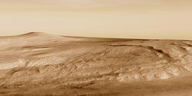
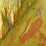
What draws scientific interest most is a big mound of layered debris filling about a third of the crater's floor. Wrapping around the crater's central peak, visible at lower right in the image, the mound stands about 5.5 km (3.4 mi) higher than the northern crater floor and about 4.5 km (2.8 mi) above the southern floor. The mound's highest parts even rise somewhat higher than Gale's southern rim.
This false-color image was taken by the Thermal Emission Imaging System (THEMIS), a multi-wavelength camera on NASA's Mars Odyssey orbiter. The view combines a daytime photo taken at visible wavelengths with a nighttime infrared image. The bluish-white tones mark areas with fine-grain materials (sand, dust) thickly covering the surface, while redder tints indicate locations where harder, rockier material lies exposed.
Gale Crater was a candidate landing site for the 2003 Mars Exploration Rover mission (Spirit and Opportunity). It now figures as one of several prospective sites for NASA's Mars Science Laboratory (MSL) mission, which will send a bigger and more powerful rover to Mars in 2011. The MSL rover will carry a much more sophisticated instrument package than Spirit and Opportunity and have the capability to drive tens of kilometers from wherever it lands.
Layer Cake
Dozens, if not hundreds of individual layers make up the mound, each archiving a sliver of the Martian past. Scientists do not know how much history is recorded in Gale's layers - an educated guess says at least 2 billion years. Studies suggest the current mound is the eroded remnant of sedimentary deposits that once filled the whole crater right to the rim and perhaps beyond.
The layers' nature is unknown as well. Possible origins include debris blown in by the wind, or volcanic ash falling from the sky. It's also conceivable that Gale Crater once contained a lake where sediments accumulated under a covering of ice.
For scientists, the probability of water playing an important role forms a big part of Gale's attraction. If water was ever abundant here, then life - or its traces - might be found.
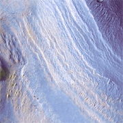
Ramp into Time?
This channel (and a few others) cuts through the mound's layers, leading scientists to conclude these are the most recent features visible. If you stood on one edge of the channel and looked across, you'd see the wall at your feet dropping layer by layer to the channel floor some 250 meters (800 feet) below you. On the opposite side, about 2 km (1.2 mi) away, the stack of layers would repeat as they climbed back up.
If the MSL rover does land in Gale Crater, this channel might offer an exploration route going into the crater's past, much as Arizona's Grand Canyon slices open part of Earth's history. The channel's lower end lies on a gently sloping pile of debris that washed down the channel and fanned onto the crater floor, which extends toward Gale's northwestern rim some 25 km (16 mi) away.
MSL might land on the smooth floor (out of the picture at top), then drive south toward the mound. Bedrock lies exposed across most of Gale's northern floor, providing geologic interest in itself.
The mound's oldest layers lie at the bottom, while younger ones stack up on top - a basic principle of geology on any planet. But there is no guaranteed access. While the channel climbs up into the mound at an average slope of only 7°, outcrops or ledges could easily make parts of the path too rough or steep for any rover.
The nameless crater at the top of the small picture spans 1.8 km (5,900 feet). Like its two smaller flanking craters, it is brimful with sediments.
The filling points to a lengthy history: this crater formed in an impact, later became buried by debris, and is only now being re-exposed. Many small craters visible on the mound resemble this one, a clue that Gale has undergone numerous cycles of erosion and deposition.
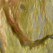
Debris Pile
The shape of this deposit resembles a fan of debris that typically accumulates at the mouth of a canyon or where a stream dumps its sediment into standing water. While the debris fan covers some layers, it appears cut in turn by a more recent channel leading northwest (to the upper left).
The channel descends across the mound's lower sedimentary layers toward the northern crater floor. High-resolution images with the MOC instrument on NASA's Mars Global Surveyor orbit suggest the lower layers include what geologists call an unconformity. This is a break in the geologic record, a gap in time caused by erosion. In this case, its length is unknown.
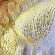
Removal Services
Gale Crater's story is long and complex and it contains numerous episodes, many of them still uncatalogued. After the impact created Gale billions of years ago, the crater has been filled with sediments and then exhumed, perhaps several times in succession.
Erosion's traces lie everywhere. The channels are one sign; others are the fine grooves running generally north-south. These may indicate wind erosion, and other features show a braided pattern suggesting flowing water.
In this part of the mound, debris appears to have washed out of the canyon at left, making a small fan at its mouth. But another kind of removal made the groove on the right. This shows features that suggest the surface collapsed as underground water escaped.
On a very much larger scale, the same "sapping" process widenedValles Marineris and notched canyons into its rim. Here, however, the undermined and collapsed area is only a few hundred meters (yards) wide and about 8 km (5 mi) long. If the quantity of water released was tiny, it still leaves unanswered the question of how - and when - the smooth, water-rich layer was deposited.
The Mound in Gale Crater