The Floods of Iani Chaos
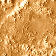
A tangle of mesas, buttes, and broken ground called Iani Chaos lies sprawled across one of Mars' longest outflow channels, the Uzboi-Ladon-Margaritifer system. This channel empties into the northern lowlands through Ares Vallis.
Iani resembles a broken slab of rock, and its shattered appearance led scientists years ago to classify it as "chaotic terrain." Wherever scientists see chaotic terrain - which occurs in numerous places on Mars - they also see signs of catastrophic floods. As they reconstruct it, huge amounts of groundwater were released when geologic faults cracked open the surface of Iani. The escaping water caused the land to subside, collapse, and erode, leaving the badlands seen today.
Iani Chaos was once in the list of landing sites that scientists are evaluating as targets for the Mars Science Laboratory (MSL), NASA's next-generation rover, planned for launch in 2011. While not chosen for MSL, Iani still offers scientific attractions to keep it on lists of potential landing sites for future rover spacecraft.
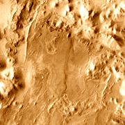
Water's role in Iani Chaos is the biggest factor drawing the interest of scientists. The main image is a mosaic of infrared photos taken by the Thermal Emission Imaging System (THEMIS) on NASA's Mars Odyssey orbiter. In addition to the collapsed landscape, however, instruments on two other Mars-orbiting spacecraft found mineralogical evidence for abundant water here.
The Thermal Emission Spectrometer (TES) on Mars Global Surveyor spotted hematite in Iani. Not long after, the OMEGA spectrometer on the European Space Agency's Mars Express orbiter detected sulfate minerals (likely gypsum) in many of the places where TES found hematite. Both hematite (an iron-oxide mineral) and sulfates require substantial water to form.
No one knows if Mars ever had life, or if it did where it was most abundant. But scientists are agreed that settling the issue will likely require samples brought back to Earth for laboratory study, which calls for a rover to be sent someday.
To land a rover safely, flight controllers need a circle 20 kilometers (12 miles) wide that is smooth, flat, and neither too dusty nor strewn with boulders. For their part, geologists want to land at a place where water has ponded and where a rover can examine many sediment layers covering a span of geologic time.
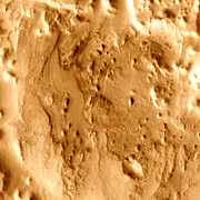
Within Iani, TES and OMEGA spotted three potential landing zones, each offering room for a roughly 20-km diameter target circle.
Landing Zone 1
Iani Site 1 offers the smoothest and flattest terrain of the three zones. High-resolution images show that it exposes perhaps a dozen thin layers of sediments, and elevations across the flat area vary by about 200 meters (650 ft) at most.
The Thermal Emission Spectrometer mapped gray crystalline hematite across the proposed landing zone. (TES was also the instrument that discovered hematite in Meridiani Planum, leading NASA to send the rover Opportunity there.)
The hematite at Iani may take the same form as that found in Meridiani by Opportunity, small spherules a few millimeters across, dubbed "blueberries" - or it may take some other form. At Meridiani, the blueberries formed by chemical precipitation within brine-soaked sulfate layers. Then, being tougher than the sulfate rocks, they weathered out and accumulated on the surface.
Landing Zone 2
The second possible rover landing site lies only a short distance southwest of the first. Forming an oval basin, the site appears to pose few engineering difficulties, being flat and relatively smooth.
In the center of the oval lies a shallow depression whose walls probably expose layered sediments. If there's a way down into the depression, a rover could possibly explore a stack of deposits ranging over an as-yet unknown period of geologic time.
The OMEGA instrument on Mars Express found that, besides the hematite seen by TES, this area also contains deposits of what is probably gypsum. Both minerals point to long periods when water pooled and saturated the ground.
Landing Zone 3
The third potential landing site in Iani may have the greatest exposures of hematite and sulfates of the three. But it would not be easy to land on. Results from the laser altimeter on Mars Global Surveyor show that elevations across the site vary by about 300 meters (1,000 feet).
Moreover, the site also appears to have many small knobs and ridges at smaller scales which could pose difficulties in landing a rover. And even should these prove no great obstacle, if the rover meets any "cliffs" much higher than about 50 centimeters (20 inches), it will be stymied.
Here as at the other potential landing sites, geological wishes and engineering capabilities may conflict.
Goundwater Floods in Iani Chaos
