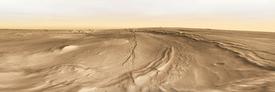
Complex Lavas in Nili Patera
Not all Martian volcanoes are cut from the pattern that produced Olympus Mons with its summit elevation of 22 kilometers (14 miles). Among the volcanoes with lower profiles is Syrtis Major.
This dark, triangular feature, visible even in backyard telescopes from Earth, was the first Martian surface marking to be detected with the crude telescopes of the 1600s. Syrtis spans some 1,300 km (800 mi) wide, yet rises only about 1 km (3,300 ft) high. On most Mars globes, it's just a low bump lying west of the Isidis impact basin. Geologists call such features shield volcanoes, and they are built from a great many thin lava flows.
The image here, assembled from dozens of individual frames taken at visible wavelengths by the Thermal Emission Imaging System (THEMIS) shows Nili Patera. This is Syrtis' summit caldera, the collapsed volcanic mouth from which the lavas flowed.
The floor of Nili Patera lies about 1,800 m (roughly 6,000 ft) lower than its western rim, which is marked by curving fractures and faults. Nili spans about 50 km (30 mi) wide and forms part of a bigger caldera complex stretching some 400 km (250 mi) in a north-south direction.
What gives Nili Patera special interest for planetary geologists is that it contains two kinds of lava flow: basalt and dacite. This is unusual for Mars, where most lavas are basalt, and the discovery showed that the planet is a volcanically complex world.

Evolved Lava
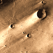
Off-center in Nili Patera is a pointed mountain with a lava flow extending mostly southwest. Laser altimeter measurements say the mountain is about 300 m (1,000 ft) high. Its slopes rise at about a 10° angle, which sounds gentle, but in fact is much steeper than the slopes of Syrtis Major itself, making the peak a volcanic cone.
The flow extends about 13 km (8 mi) and spreads from the cone to a flow front about 13 km wide. It's about 80 m (270 ft) high and has steep edges.
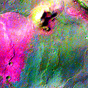
Using multiple infrared "colors" from THEMIS to study the surface, scientists have processed the images to reveal differences in rock composition. Seen in false colors, the lava flow from the volcanic cone appears bright magenta, while floor of Nili has a blue and blue-green color. (Note the two small craters as common reference points.)
Translated, the colors indicate radically different lava types. Basalts are the commonest lava rock in the solar system. The Hawaiian Islands, for example, are entirely built of basaltic lava flows, and just about all of the planet Venus appears covered in basalt flows.
The magenta flows seen here, however, are dacite, a different kind of lava. Dacite emerges from a volcano when the molten rock becomes rich in silica minerals rather than the iron minerals that dominate basalt. Geologists call dacites "evolved" lavas, and a dacite flow indicates chemical changes deep in a volcano.
In the case of Nili Patera, this dacite flow was solid evidence that Mars erupts lava in flavors other than common basalt. (Elsewhere on Mars, geologists have also spotted rocks similar to terrestrial granites, furthering the idea of Mars having a geologically diverse crust.)

Fissure Cones
About 35 km (22 mi) southeast of the dacite peak lie two curving faults or fissures in the ground. Along one of the faults a chain of small cinder cones has grown. These probably erupted when the fault made it easy for molten rock and gases to reach the surface of Nili Patera.
What kind of lava came out of them? According to the multi-wavelength images from THEMIS, these cinder cones erupted regular basalt, not dacite. Large volcanoes on Earth often show place-to-place variations like this, so the difference is not too surprising.
Bouncing Bits
The summit of Syrtis Major, despite its low altitude, is one of the less dust-covered places on Mars overall. Winds from the northeast have swept across the volcano, leaving streaks to mark their direction. Downwind from many craters lie bright tails of dust which accumulated in the craters' wind-shadow.
Wind-shadows form when the upthrust crater rim causes the airflow to become turbulent. The result is a slackening of wind in the zone directly behind the crater. Any airborne dust that drifts into the shadow zone has a good chance of settling out of suspension onto the ground.
Away from the shadow zones, winds can drive larger particles (sand, for example) to bounce across the ground. When sand particles land, they typically knock the smaller dust particles loose from the surface and they are carried off by the wind.
But the bouncing sand grains don't fly downwind forever: If the wind slackens, they'll pile up, depositing the raw materials for making dunes, just as happens in desert regions on Earth.
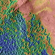
Sand Scrawls
This false-color image from THEMIS combines the visible wavelength view with a nighttime infrared one. At night, temperatures on Mars plummet, and fine-grain materials such as sand and dust become very cold. Rocks and hard materials soak up heat during the day and hang onto the warmth better as night's chill descends.
Looking down from orbit on Nili Patera in the predawn hours, THEMIS sees cold sand and dust and relatively warm rocks. With thermal differences translated into false colors (bluer colors indicate colder temperatures), the dunes stand out. In contrast, the broad floor of Nili - a sheet of hard, basaltic lava with little dust on it - glows warmer and appears here in reddish colors.
The dunes' shape is what geologists call a barchan (pronounced bar-kan). By itself, one barchan dune forms a familiar boomerang shape, but when there's enough sand available, barchans merge and join, producing a complex field of dunes. If enough sand is present, the underlying surface will be covered completely with dunes, and they will merge to become long lines that look like a snapshot of the ocean's surface.
While winds are delivering sand to the barchan field, they are also removing particles from it as well. Is this field, then, in a steady state? Hard to say without a longer baseline of observations. Ask again in 10 or 20 years!
Nili Patera's Complex Lavas