New orbit gives THEMIS better looks at Mars minerals
A slow drift in the orbit of NASA's Mars Odyssey spacecraft that mission controllers started nine months ago is now giving an ASU instrument on the spacecraft a better and more sensitive view of minerals on the surface of Mars. The instrument is the Thermal Emission Imaging System (THEMIS), an infrared and visual camera operated by ASU's Mars Space Flight Facility.
The maneuver to change Odyssey's orbit began Sept. 30, 2008, and ended June 9, 2009, with a five-and-a-half-minute thruster firing. The rocket burn fixed the spacecraft's track so that THEMIS looks down on the planet at an earlier time of day, 3:45 in the afternoon instead of 5 p.m.
Odyssey's two-hour orbit is synchronized with the Sun, so that the local solar time on the ground remains the same whatever part of Mars the spacecraft is flying over. As Odyssey travels on its north-to-south leg over the day side, the local time below the spacecraft is now 3:45 pm; similarly, the local time is 3:45 a.m. under the spacecraft as it flies the south-to-north leg of each orbit on the night side.
Warmer ground means better data
"The new orbit means we can now get the type of high-quality data for the rest of Mars that we got for 10 or 20 percent of the planet during the early months of the mission," says Philip Christensen of ASU's School of Earth and Space Exploration, part of the College of Liberal Arts and Sciences. Christensen designed THEMIS and is the instrument's principal investigator.
One important finding based on early-mission THEMIS data was the discovery of chloride mineral deposits in the ancient southern highlands. These salt beds are possible relics of a warmer and wetter epoch on Mars and may have something to tell scientists about a Martian biosphere, past or present.
"Imaging Mars earlier in the afternoon means that THEMIS sees a warmer surface," explains Christensen. "And this makes a greater temperature difference with the nighttime measurements. The stronger contrast brings out more clearly the composition variations in the surface rocks."
In another operational change, Odyssey has begun in recent weeks to make observations other than straight downward-looking. This more-flexible targeting allows THEMIS to image some latitudes near the poles that never pass directly underneath the orbiter. In addition, the sideways views let THEMIS fill in more quickly gaps in coverage left by previous imaging, and they will also permit stereoscopic, three-dimensional images.
"At visual wavelengths, THEMIS has photographed about half the Martian surface," says Christensen. "We're really looking forward to filling the holes in the coverage."
Other News & Discoveries

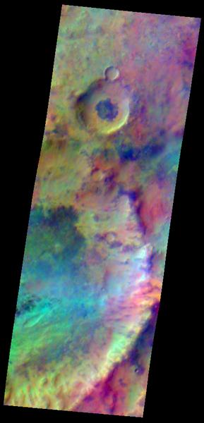
Pastel Colors Swirl
.. across Mars, revealing differences in the composition and nature of the surface in this recently taken false-color infrared THEMIS image. Showing an area 31.9 kilometers (19.8 miles) by 88.3 kilometers (54.9 miles) in the southern highlands of Mars, the image is a result of the earlier orbit time for Mars Odyssey and THEMIS. In the image, dark areas mark exposures of relatively cold ground with abundant bare rock, while warmer basaltic sand covers the light blue-green regions. Reddish areas likely have a higher silica content, due either to a different volcanic composition or to weathering.
NASA/JPL/ASU image
Download Original