When Mars was still young, more than four billion years ago, a large asteroid sailed out of the sky and slammed into an area known today as western Arabia Terra. The object hit hard enough that it blasted a basin at least 280 kilometers (175 miles) wide. The basin is now named Aram Chaos.
As many millions of years passed, into this yawning bowl drifted sediments of many kinds - wind-blown dust, sand, and volcanic ash. The Martian climate was wetter then, so the crater-filling debris became saturated with water, which likely froze as the climate shifted and cooled.
Then something triggered the ground ice to melt. Perhaps the ice-locked sediments trapped residual heat from the original impact or, more likely, molten rock moved into the fractured ground below the basin. (The floor of Aram has a gentle upward dome, which supports this idea.)
Whatever happened, warmth melted the ground ice, causing the sediments to collapse in a chaotic network of valleys, mesas, and hills. These show most clearly in the south and west parts of Aram. The liberated meltwater pooled in the basin, eventually rising to overflow the basin rim on the eastern side, where in a geological instant, a surging flood carved a narrow channel leading down into Ares Vallis.
A dramatic story, but Mars was not finished with Aram.
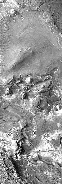
Following the collapse and formation of the chaotic terrain, Aram refilled with water, draping sediments across part of the chaos underneath. High-resolution images show the sediments laid down in this second era of deposition varied greatly, suggesting that environmental conditions were changing. Some deposits became hard layers of caprock on mesa tops, while others were softer and weathered more easily.
One of the layers in the middle of the sequence caught scientists' eye early. Data taken with the Thermal Emission Spectrometer (
TES) on NASA's Mars Global Surveyor orbiter revealed in Aram a widespread expanse of the iron-oxide mineral hematite. This mineral usually forms in association with water, attracting the attention of scientists as they search for evidence of Mars' habitability in the past.
In fact, the
Aram hematite deposit is the second-largest known on Mars, following the deposit in
Meridiani Planum, another TES find. On the strength of the TES discovery in Meridiani, NASA sent the Mars rover Opportunity there, where it found abundant hematite in the famous "blueberries." These are hematite-rich nuggets called concretions, which formed within water-saturated sediments.
In more recent years, data from the OMEGA instrument on the European Space Agency's
Mars Express orbiter shows extensive deposits of sulfates. These are other water-related minerals that reinforce and supplement the picture drawn by TES.
This false-color image of Aram Chaos is a mosaic of frames taken by the Thermal Emission Imaging System (
THEMIS), a multi-band camera on NASA's Mars Odyssey orbiter. THEMIS takes images in five visible and 10 infrared wavelengths. In this mosaic, which combines daytime and nighttime infrared imaging, areas where sediments are tougher and rockier appear in warmer tones, while surfaces covered in fine-grain materials - sand, dust - appear in cooler tones.

Layer Cake
Sediments filled Aram to the brim originally. Then, as the subsurface ice melted and escaped, the terrain collapsed, making the center of Aram a lake. Let your eye draw a line following the inside edge of the chaotic terrain, and you can trace the outline of the lake: this "inner basin" has roughly half the size of Aram's outer rim.
Across the center of the inner basin lies a smooth-topped mesa. This is the remnant of the youngest layer scientists can identify within Aram.
The inner basin collected sediments just as all of Aram did when it first formed. It's unclear to scientists, however, whether water filled the inner basin continuously or if flooding came and went in stages.
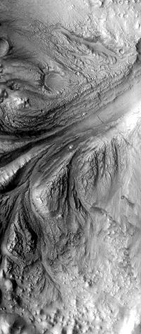
High-resolution images (such as the THEMIS frame below right) show many instances of smooth layers covering chaotic landforms - and never the reverse. This suggests numerous episodes of smooth sedimentation, probably in standing water.
Yet even if the lakebed was dry most of the time, water was certainly involved in making one layer: the hematite. From its exposures on the floor of the inner basin, scientists conclude that the hematite layer lies about midway within the sedimentary stack. It thus represents a single, indisputably wet episode in Aram's history.
Scientists think the hematite formed as water soaked minerals such as goethite at low temperatures for long periods of time.
How old is the hematite? Without rock samples in hand, scientists can only estimate its age based on the number of craters the layer contains. This evidence suggests Aram's hematite layer is younger than the Meridiani hematite, by perhaps 750 million to a billion years.
With an estimated age for the Meridiani Planum hematite of about 3.5 billion years, this places Aram's lake around 2.7 to 2.5 billion years ago. This is later in Martian history than most scientists think the climate would allow a lake to exist at the surface. But no one is worrying yet about the discrepancy - while the relative ages look good, the actual dates are far from precise.

Crumbling Underfoot
If you took a large, flat piece of chocolate, froze it, then smacked it hard on a table, you'd see a fracture pattern like the chaotic terrain in Aram. In some places - near the south rim, for example - only small hills and blocks remain of uncollapsed terrain, while elsewhere the slabs extend a dozen kilometers or more across.
In some areas, the cracks reflect the underlying topography, as in this crater, which was already on the floor of Aram when the sediments first filled it.
Undermining the surface by meltwater escaping is fairly common process on Mars. Scientists interpret this as evidence for widespread water on the planet in ancient times.
The chaotic pattern also implies something that's exciting to think about. In the blocks and mesas that have not collapsed - especially the larger ones - ground ice might still lie near the surface even today.

Down the Drain
The lake that filled Aram must have overflowed at least once because the waters carved an 80-km (50-mi) long channel through the impact basin's eastern rim. The channel averages 15 km (9 mi) wide and 2,500 meters (8,200 feet) deep; it meanders only a little on its course from Aram to Ares Vallis.
The area inside Aram near the outlet shows many grooves (see the THEMIS image at right), which scientists interpret as being cut by the surging floods that thundered out of Aram into the Ares-bound channel.
The warm tint of these sediments in the false-color view indicates a greater amount of hard sediments. This fits a pattern in which lighter and more easily eroded sediments were washed away in the floods.
How much water poured through there at peak is unknown. The water added to the floods that passed through
Ares Vallis, but that valley already existed.
Along the walls of the Aram channel, landslides have narrowed the channel's course and dumped debris in its path.
Many layers exposed in the walls of the channel show a long sedimentary history for Aram. Ridges of harder sediments alternate with grooves gouged into more easily eroded layers - this pattern suggests repeating cycles of deposits.
The view from orbit shows Aram Chaos has a complex history. Scientists have begun to identify landmarks in that history, but the story is a long, long way from being complete.


