Target Zone: Nilosyrtis?
Syrtis Major is a large dark region on Mars visible from Earth even in small telescopes. Its darkness comes from lava flows blown free of dust, for Syrtis is a gigantic, windswept volcano. Rising only slightly above its surroundings, Syrtis spans more than 1,300 kilometers (800 miles) wide.
Just north of Syrtis, the Martian highlands end in a region called Nilosyrtis. Here the highlands break up into isolated peaks and mesas in a transition zone scientists call the crustal dichotomy. This is a relatively abrupt change in elevation - a drop averaging 5,500 meters (18,000 feet) - that encircles the planet, marking a boundary between the highlands to the south and the vast lowlands that cap the northern half of Mars.
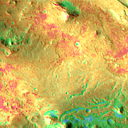
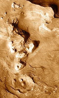
These scene here shows part of the edge where the highlands are disappearing. On the left is a large, ruined crater about 90 km (55 mi) wide and roughly 3,000 m (10,000 ft) deep. Layers of sedimentary deposits fill its floor and line the channels between the hills and mesas that extend downward toward the east (right) into the lowlands.
In the dead center of the frame, where the crater's northeastern wall would be, lies a candidate landing site once identified by scientists for NASA's next Mars rover, the Mars Science Laboratory, or MSL, due for launch in 2011.
MSL's mission is to find deposits that will tell scientists if Mars has ever been a home for microbial life. The Nilosyrtis site caught scientists' interest because in places its sedimentary layers contain water-altered clay minerals called phyllosilicates. These may preserve traces of ancient life.
Nilosyrtis is no longer among the potential landing sites for MSL, due to various reasons. However, it still offers scientific attractions to keep it on lists of potential landing sites for future rover spacecraft.
This mosaic of the Nilosyrtis site merges numerous frames made by the Thermal Emission Imaging System (THEMIS), a multi-band camera on NASA's Mars Odyssey orbiter. THEMIS researchers combined daytime and nighttime infrared views to create a false-color mosaic that shows the nature of the Martian surface.
In essence, areas covered with dust, sand, and fine grain particles appear in tones of blues and greens. Harder sediments and outcrops of rock, however, show in shades of yellow, orange, and red.
Ground Zero
As originally planned, the middle of the circular landing zone (20 km or 12 mi in diameter) lies at the center of the close-up image at left, which is 35 km (22 mi) square. The hill at the top of the closeup image rises about 600 m (2,000 ft) above the landing zone's elevation.
The landing zone and its immediate surroundings were selected as a candidate because they contain sediments identified as phyllosilicates by scientists using the OMEGA instrument on the European Space Agency's orbiter, Mars Express.
The existence of phyllosilicate minerals indicates that water was present in the ground at some point. Water is essential to life on Earth and, presumably, would have been equally essential in any Martian biosphere. Thus the search for possible ancient habitats on Mars revolves around places that show evidence for water's effects.
But science is only half of the story: First, any lander has to get down safely. According to high-resolution images from NASA's Mars Reconnaissance Orbiter, the ground at the landing site appears relatively flat and neither too dusty nor too rocky.
MSL is designed with a minimum driving range of 20 km (12 mi), and with any luck, future rovers should far exceed that. Thus even if a rover were to land on a scientifically less-interesting piece of ground, mission controllers can drive off in search of a better one to study.
Long Mesa
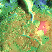
One interesting site lies about 20 km to the northeast of the landing zone. This long, flat-topped ridge, about 200 m (700 ft) high, is likely a remnant of a layer (or several layers) that once covered a much greater area.
On Earth such features give geologists a detailed look at a sequence of rock layers, with the oldest at bottom and the youngest on top. Such layers always open a window into Earth's history, and the same surely holds for Mars as well.
Close-up images (such as at right) taken by the HiRISE camera on the Mars Reconnaissance Orbiter show the long mesa flanked with debris that has weathered out of the mesa's layers and accumulated at the foot of the slope.
A rover might never visit this mesa - and its upper layers might also prove too steep to climb. But the rover could explore the rubble around the base of the mesa. This would let scientists study rock layers that remain out of reach on the slopes above.
History Book
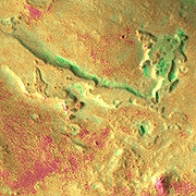
Another "history book" of sediments lies within a nearly filled crater at the bottom of the big mosaic. This crater is about 70 km (45 mi) wide and 2,000 m (6,500 ft) deep. Its northern rim is sliced open by a deep channel that descends to the Nilosyrtis floor.
At one point in the Martian past, this crater must have been brimming with water. Some event caused the water to overflow the rim to the north, and erosion promptly cut the channel, which widened and deepened as the draining flow continued. At greatest, the channel is 15 km (9 mi) wide and 1,000 m (3,300 ft) deep. Its snaking course runs for 60 km (37 mi).
As the waters drained, they left behind layers of sediments that may have accumulated when a lake filled the crater. The floor of the crater is divided into blocks and hills (see the THEMIS visible wavelength image at right) that stand 50 to 100 m (150 to 330 ft) high, separated by channels filled with fine-grain deposits.
As with all sedimentary layers, the blocks will preserve chemical and physical features that could tell scientists much about the time when they formed.
The chances of a rover ever driving up the big channel and into the crater are remote, to say the least. But if it happens, this will open a new chapter in the book of Martian geological history.
Nilosyrtis
Vital Statistics
Long Mesa
Rocks and deposits from a high mesa near the MSL landing site have collected in a jumble at the foot of the mesa's slopes.
NASA/JPL/University of Arizona
Download Original
History Book
Blocks of sediments within the crater testify to bygone eras when the crater may have been held a lake. Thin, blade-like ridges show where harder minerals collected in cracks and faults and then emerged as softer surrounding sediments wasted away.
NASA/JPL/Arizona State University
Download Original