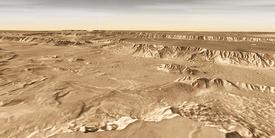
East Melas Chasma
The gigantic equatorial rift named Valles Marineris has intrigued Mars scientists ever since the feature was discovered in the early 1970s. As generations of spacecraft have sent back ever-sharper images, our picture of the canyon has grown steadily more detailed - and interesting.
NASA is planning to launch (in 2011) a follow-on rover to Spirit and Opportunity, the highly successful Mars Exploration Rovers that landed in 2004. Dubbed the Mars Science Laboratory (MSL), the new-generation rover will have a minimum driving range of 20 kilometers (12 miles) and instruments designed to look for evidence of former life.
Scientists are sifting potential landing sites for MSL. Because water appears essential to any form of life, locations with evidence of a wet past are high in priority. Among the sites under consideration for MSL - but ultimately rejected for various reasons - was a spot in eastern Melas Chasma, roughly in the center of Valles Marineris. (Melas is also home to another once-favored MSL site 450 km [270 mi] to the west.)
While neither Melas site made the final cut for MSL, they still offer scientific attractions that would keep them on lists of potential landing sites for future rover spacecraft.
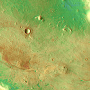
The big image is a false-color mosaic of photos taken by the Thermal Emission Imaging System (THEMIS), a multi-wavelength camera on NASA's Mars Odyssey orbiter. With Mars Odyssey flying in a near-polar orbit, THEMIS can scan almost all of Mars, capturing its surface in 5 visible colors and 10 infrared ones. This mosaic is made of infrared frames taken by day and by night.
The false colors hint about the nature of the ground material. Reddish colors show where rocks and hard deposits are plentiful, while greens and blues indicate the areas where gravel, fine sand, and dust particles predominate.
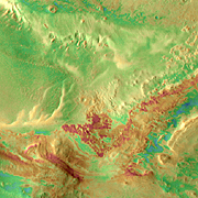
Landslide?
While the piece of ground doesn't look very exciting, scientists studying it closely have found that high-resolution images show several kinds of surface deposits. These may include the water-laid sediments scientists are hoping to find.
Failing that, a rover could drive close to the crater, which is about 3 km (2 mi) wide. The impact that made the crater would have excavated beneath the surface, perhaps bringing up sediments and scattering them as debris.
Should that prove fruitless, toward the bottom of the image lies a low bump of hill. It is about 8 km (5 mi) long and 300 m (1,000 ft) high. Scientists suspect the hill is an outcrop of a long-sought-after material seen in many places in Valles Marineris. Dubbed the "interior layered deposits," or ILDs for short, these have drawn scientific interest and speculation since the 1970s.
While the exact nature of the ILDs remains a mystery - and they probably vary from place to place - they appear to contain volcanic ash and other debris, perhaps including sediments laid down underwater. That makes them a high-value target for the rover.
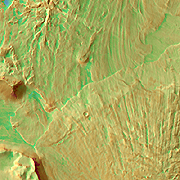
Head for the Hills
But the low hill may prove unsatisfying also. If so, and if MSL is in healthy shape, scientists would likely drive the rover another 30 km (20 mi) farther south. That would place it among a much larger field of outcrops and layers.
These ILDs are especially attractive because they contain sulfate minerals, as detected by the OMEGA spectrometer on the European Space Agency's Mars Express orbiter. Finding sulfates is a big tipoff that water has saturated the ground.
How much water, and for how long, and when during Martian history are all questions to be answered. And beyond this basic geological survey lies the biggest question: Did Mars ever have life? And if so, do these deposits record traces of it?
Look Out Below
While no flight engineer would aim to land a rover in this rough landscape, it offers an intriguing (and safe) look from high above. Two landslides, one from the northern wall and a second from a range of hills to the south, met in mid-valley, with the leading edge of the southern slide riding over the northern.
The northern slide therefore came first, and it was a great deal larger (as the big image shows). The northern slide also seems to have fallen from two source regions on the wall simultaneously. The two halves of the northern slide appear to join where they run out onto the valley floor, but they not overlap.
Elsewhere in the big image lie other great landslides, including several that show softer details. These appear partly buried by debris, which may have been volcanic ash falling from the sky, or sediments left by floods in the valley.
Valles Marineris is an enormous feature - long enough in total to stretch from Los Angeles to New York City. Even Melas is dauntingly large - 300 x 500 km (200 x 300 mi), roughly the size of Iowa.
Obviously, only a tiny portion of this grand feature will ever be explored. But the scientific payoff promises to be substantial: Locked in those interior layered deposits, scientists think, is a long history of Mars. Even if the ILDs prove to contain no traces of life, the deposits in Valles Marineris will continue to exert a powerful pull on scientists' interest - and their imaginations.
East Melas Chasma