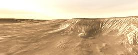
History's Layers in Hebes Chasma
On the northern side of Valles Marineris on Mars lies a closed geological depression named Hebes Chasma. In outline, Hebes looks like a micro-version of the gigantic valley - but it extends only about 320 kilometers (200 miles) long and stretches 130 km (80 miles) wide at its widest. Still, Hebes is about 5 to 6 km (16,000 to 20,000 feet) deep in the region seen here and as with most parts of the Valles Marineris system, landslides scar its walls.
Yet Hebes isn't simply a tiny sibling. Much of its interior is filled with a large mesa measuring about 120 km (75 miles) long by 40 km (25 miles) wide. The mesa's top reaches nearly as high as the surrounding terrain. No other Martian canyon has a similar feature.
The mesa poses a puzzle for scientists. It is a stack of rock and debris layers, but these appear to have a different geological structure than the walls of Hebes. This makes the origin of the mesa's layers a question of prime importance for Mars scientists.
This false-color image was made from frames taken by the Thermal Emission Imaging System (THEMIS), a camera that views Mars in 5 visual and 10 infrared "colors." THEMIS orbits aboard NASA's Mars Odyssey spacecraft.
The mosaic combines high-resolution images taken in daytime at visible wavelengths with heat-sensing infrared views taken late at night. The colors reveal the mesa's surface properties by mapping their thermal inertia, a measure of how fast the ground warms up and cools off.
High thermal-inertia materials (coded in reddish colors) are slow to heat and cool; they tend to be rockier and more solid. (Think of bedrock, loose boulders and rocks, and coarse gravel.) Yellows, greens, and blues, on the other hand, indicate low thermal inertia areas covered in smaller-size gravel, sand, and dust particles.
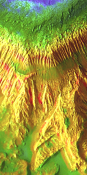
Layer Cake
The first thing scientists note about the mesa is that its slopes are weathering differently than the walls of Hebes - in places the mesa has fine-scale fluting that the canyon walls lack. Second, the thermal inertia data say that the individual mesa layers have different physical properties. Both observations suggest the mesa and canyon walls are made of different materials.
Sharp images from THEMIS and other imaging data reinforce this suggestion. Bottommost in the mesa is a thick layer, tinted yellow in the false-color image. The color hints the layer is made of medium-size sand particles and larger grains. The weathering style of the layer - the large size of the flutes - suggests the grains are partly cemented and solidified. In a few places, the bottom unit also shows red streaks that indicate exposures of bare rock and hard sediments.
Higher up the slope is a thinner band with a smooth greenish tint in the false-color image. This layer has sand-size particles as well, but they appear to be loose. It's likely they are debris grains from higher up the slope that fell and slid down to collect here.
The next higher unit - and thus younger in geologic terms - also has medium sand grains, but the fine-scale fluting shows they are not well-cemented to each other. Comparing the bottom unit with this one, geologists would say the bottom unit resists erosion better and is likely to be tougher and more consolidated.
Above the finely fluted unit is a band colored strongly green in the false-color image. This also shows a wavy structure suggesting it was laid down and then deformed. The differences suggest this layer may have been deposited wet or in connection with water somehow.
Finally, the top of the mesa shows (in blue) a layer of very fine sand, plus dust that has fallen out of the air.
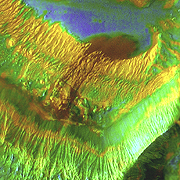
Dark Flow
At first glance, this dark patch on the northern side of the mesa looks like it might be a lava flow. But THEMIS data show it is more likely a flow of loose, medium-size particles, probably dark basalt sand grains. It lacks the thermal properties of solid rock, which would be the case with an actual lava flow.
A puzzle remains, however, regarding what caused this loose material to flow from the mesa. It could have begun sliding due to cracks in the layers making the slope unstable. But another possibility is that a small outburst of groundwater or melting ice weakened the rocks, making a debris slide more likely. What are the chances of this happening?
Water definitely pooled in parts of Hebes long ago. Data collected by the OMEGA spectrometer on the European Space Agency's Mars Express orbiter identifies places in eastern Hebes that are rich in sulfate minerals. These form by the interaction of water and rocks.
But whether the origin of this dark flow is wet or dry remains an open question for now.

Rocky Jumble
Weathering has whittled the sides of both Hebes Chasma and its mesa, enlarging the trough and shrinking the layered stack. The debris winds up filling the hollows between the mesa and the trough walls. Yet the mesa and canyon walls are eroding in ways that suggest they are made of different materials.
The canyon walls have developed a large-scale spur-and-gully topography that geologists say reflects a tough and relatively homogenous nature for the wall rocks. Paralleling what is seen commonly in Valles Marineris, the walls of Hebes may be built of massive lava flows.
The reddish patches at the bottom of the slope show where bare rock and large boulders lie exposed at the surface. Higher up, finer-grain materials coat the spurs and line the gullies. Still higher on the slopes, the ground is covered with medium-size sand. And fine sand and dust coat the flat surface outside Hebes.
So what force or forces created the geological puzzle box that is Hebes Chasma? One solution, proposed in the early 1980s, may account for the current observations.
In this model, Hebes began as a chain of pits and small troughs aligned with geological faults, similar to those seen now in Coprates. As faulting continued, escaping water and melting ice in the ground widened the trough by undermining the walls and causing landslides.
At some point debris started to collect within the growing canyon. Ash and fine-grain materials blew in or fell from dust clouds in the air. During wet periods in some climate cycles, Hebes may have harbored a lake that accumulated debris.
Eventually, the climate shifted back toward its present cold and dry state. As this was going on, Hebes Chasma continued to widen and enlarge as landslides collapsed its walls. For its part, the mesa also shrank a bit as its stack of sediments eroded at their edges.
Then at some point in ages past, Hebes stopped growing, and both it and its mesa settled into their present form.
Hebes Chasma