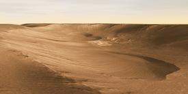
Landslides and Debris in Coprates Chasma
Not far south of the Martian equator runs a vast east-west canyon system named Valles Marineris. One of the most spectacular features on a geologically spectacular planet, Valles Marineris has posed a challenge to scientists since they first spotted the huge rift back in the early 1970s.
How did such a gigantic structure - more than long enough to stretch from Los Angeles to New York - ever form? A few parts of the canyon system offer some clues.
Toward the eastern end of Valles Marineris lies Coprates, a region consisting mainly of a wide trough named Coprates Chasma. Paralleling it to the south runs a narrower chain of linked pits and depressions called Coprates Catena. In Coprates Catena - shown in part in this THEMIS image taken at visible wavelengths - geologists can spot evidence for how Valles Marineris formed.
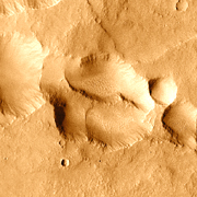
Collapsing Pit
The canyon began to form following uplift in the neighboring region of Tharsis to the west. The stress of uplift opened numerous parallel cracks or faults in the crust; these radiated generally eastward from Tharsis.
As the faults opened, water in the ground escaped along the fault lines, undermining the surface and causing it to collapse. This produced roughly parallel chains of pits and depressions. Where undermining and collapse were widespread, individual pits and ovals merged into connected valleys and troughs.
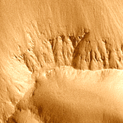
Layered Wall Rock
Scientists are unsure of the exact nature of the rocks that make up the plain in which Valles Marineris formed. However, its closeness to the Tharsis volcanic region hints strongly that the ground is made of layer after layer of lava flows, probably mixed with deposits of volcanic ash that fell out of the air following big eruptions.
Images of rocks poking out of the canyon walls nearly always show layers. Some layers appear tougher than others, and a mix of lava and ash would naturally vary in resistance to erosion, just as seen. Such partly porous materials could hold a great deal of groundwater.
On Earth, slopes like those in the pits and troughs are usually loose and erode quickly. But Mars lacks Earth's rainfall - at least in its present climate - and slopes in the canyon could last apparently unchanged for millions of years. It is likely also that the rock strata in the walls preserve a long geo-history of Mars, one that planetary scientists would love to be able to read.
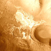
Bathtub Ring
This white feature lies at the bottom of a trough about 3,600 meters (12,000 feet) deep. It is probably a deposit of salts and other minerals left by the evaporation of a temporary lake which filled part of the trough.
A recent study examined a fan-shaped deposit just out of the image frame to the left (west); the study's authors concluded the fan was a delta made of debris washed into a lake of standing water. As the lake dried up, the last minerals held in solution in the water would precipitate out, leaving a deposit rich in salts.
If escaping groundwater likely created these depressions and Valles Marineris itself, it's reasonable to wonder why all the troughs don't have such bright deposits on their floors. No one knows for sure, but scientists suggest evaporite layers could be more widespread than they appear to be: many deposits may have been buried by later wind-blown sediments or by loose debris cascading down the wall slopes.
The THEMIS camera has been imaging Mars in the visible and infrared parts of the spectrum since February 2002. Nearly 21,000 THEMIS images have now been blended to create a global view of Mars.
Coprates Chasma