Floods in Athabasca Valles
The freshest outflow channel on Mars is Athabasca Valles, which lies 1,000 kilometers (620 miles) southeast of the large volcano Elysium Mons. Like Granicus Valles, Athabasca was carved by water that burst out of fissures in the ground.
In the case of Athabasca, the cracks (named Cerberus Fossae) probably opened under stress from the growth of both Elysium Mons and Tharsis, a large volcanic region lying more than 5,000 kilometers (3,000 miles) to the east. Geological evidence suggests the Cerberus floods erupted in several stages, perhaps as tectonic forces pressurized the groundwater in the region. Not far away, and likely sharing a similar origin, are other outflow channels, such as Marte, Grjótá, and Rahway valles.
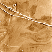
Athabasca's age comes from counts of craters in all sizes on the valley floor and surroundings. Because the craters here are relatively small - the largest crater, at right center, is 20 km (12 miles) wide - scientists say age dating is open to a lot of error. Based on the counts, however, the valley is between 2 million and 30 million years old. If true, that makes it the youngest outflow channel on Mars.
This colorized mosaic image, taken in infrared light during late afternoon, shows part of the Cerberus fissures and the first 250 km (155 miles) of Athabasca Valles as it extends to the southwest (lower left). The camera was the Thermal Emission Imaging System, or THEMIS, aboard NASA's Mars Odyssey orbiter.
Infrared images taken by THEMIS record ground temperatures. During daytime, flat surfaces covered with dust or fine sand grow warmer than expanses with bare rocks and hardened sediments. Thus areas that appear bright in the image are typically dusty or sandy, while dark areas are usually rockier or less dust-covered.
The bright streaks extending to the lower left from the fissures are wind-blown sediments, probably sand and fine particles. This debris may have been erupted along with the water that burst out of the crack, or it may be loose material from elsewhere that collected downwind from the crack.
Gusher
When the fissures opened, subsurface water burst out of the ground, spreading on both sides of the break. As the water continued to flow, it quickly found low ground leading to the southwest. Surging down this natural route, the flood carved a path, guided in part by a low ridge.
The surface in this part of Mars is generally flat, and the slope of Athabasca Valles is quite shallow, dropping only 1 part in about 2,000. The valley channel is about 70 meters (230 feet) deep.
Scientists are uncertain how much water erupted. But they suspect the flood came in several distinct episodes, or in repeated outbursts. Estimates of the volume range from 10,000 to 10 million cubic meters (350,000 to 350 million cubic feet) per second. For comparison, the Mississippi River's flow averages 17,000 cubic meters (600,000 cubic feet) per second.
Islands In the Steam
The racing water reshaped hills and high ground in its path, giving them streamlines and in places depositing debris downstream behind.
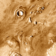
Impact craters stand at the heads of some streamlined islands. This occurs because blankets of rocky rubble thrown out in the impact protected the ground like a breakwater protects a shore from waves. Elsewhere in the stream, detailed images with the MOC instrument on the Mars Global Surveyor orbiter show low, aligned ridges in the channel. These were left by scouring water as were giant ripples - underwater dunes, actually.
In other parts of the valley floor are enigmatic features that resemble what volcanologists call rootless cinder cones. These form when lava flows over ground that is saturated with water or ice. The lava's heat turns the water to steam, and this explodes up through the flow, building a cinder cone 10 to 100 meters (33 to 330 feet) high.
Another explanation is that the features may be similar to the pingos that occur in Earth's arctic regions. A pingo is essentially a giant frost heave: the surface is pushed up by the expansion of a pocket of ice.

Lava Flow
Besides water, molten rock also flowed in Athabasca - in fact, the valley plains were built from many sheets of lava. One theory for the origin of the Cerberus fissures is that as molten rock forced its way upward along a fault, it widened a crack which eventually reached the surface. At that point, out came water and lava, in eruptions that may have alternated.
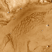
In the channel shown in the small image, a lighter path snakes down the dark, rocky center of the flow. The lighter tint suggests this material is less rocky than the edges of the lava flow. This might mean water flowed last in the channel, leaving a deposit on top of the lava - or it could be wind-blown debris collecting in the channel bed.
Impact
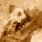
The tiny crater in the image is the result of a meteorite's impact. The crater is only 1.2 km (4,000 feet) across, about the same size as Arizona's Meteor Crater. From the asymmetric shape of the light halo around the crater, it appears the meteorite was traveling on an oblique path heading generally southwest.
The dark material lying outside the debris splash pattern may be fresh, rocky lava lying on top of a lighter-tinted flow that, in turn, might be spillover from the valley channel. This could have resulted from a two-stage eruption. A more likely scenario, however, is that the channel lavas are lightly covered by sediments deposited by one of the floods, and the dark material stood high enough not to be engulfed.
Puzzle Pieces
As lava flowed down Athabasca Valles, it cooled at the surface while remaining molten below, producing a chilled, stiff skin over a fluid interior. Pushed and shoved by currents, the skin on such a flow is brittle and breaks in slabs. Although temperatures don't compare, this kind of lava flow behaves a lot like pack ice in Earth's Arctic Ocean.
Here, THEMIS sees the "lava rafts" have surfaces that are smoother and coated with finer-grain material. In between, in what would be open water on Earth, lie channels of dark, rough lava.
Some scientists have proposed that the ground here and in similar-appearing locations elsewhere in Elysium actually contains ice near the surface. The rafts, then, would not be slabs of hardened lava, but dust-covered blocks of ice. This notion has not been widely adopted by other scientists. Yet it is possible that some underground water or ice could survive here if buried deep enough.