Water in Meridiani Planum
When Mars Exploration Rover Opportunity landed on Meridiani Planum in January 2004, it quickly found what it had been sent from Earth to find: evidence of liquid water in the martian past.
Opportunity was targeted on Meridiani because remote sensing from orbit by the Thermal Emission Spectrometer (TES) on NASA's Mars Global Surveyor showed portions of Meridiani contain up to 20 percent gray crystalline hematite at the surface. Hematite is an iron-oxide mineral, and the gray crystalline variety forms mostly in association with liquid water.
On the ground, Opportunity discovered the hematite lies within BB-sized spherules, dubbed "blueberries" by scientists. Loose blueberries litter the surface at the landing site, making what geologists call a lag deposit. Blueberries are also embedded within outcrops of soft, layered sandstone rocks that show evidence of being deposited in shallow flowing water.
As geologists reconstruct it, the blueberries formed when strongly acidic groundwater drenched the basaltic sandstone, which was rich in goethite, another iron-bearing mineral. The water altered the goethite into hematite, forming spherules within the rocks. Then, over unknown ages, as the acid-rotted sandstones weathered away, the tougher spherules came free and collected on the surface.
How long was Meridiani wet? Opportunity examined outcrops in microscopic detail. But even the biggest exposure of bedrock the rover has seen so far measures less than 10 meters (33 feet) high, so estimating a duration is difficult. Instead, it helps to step back and look at the big picture from orbit.
The large image here shows a false-color view of part of Meridiani Planum, about 400 kilometers (250 miles) northeast of where Opportunity landed. The image was taken by the Thermal Emission Imaging System (THEMIS) on NASA's Mars Odyssey orbiter. THEMIS is a camera that images Mars in 5 visible and 10 infrared "colors." The image combines daytime and nighttime infrared views. Reddish areas have more rocks and hardened sediments, while bluish areas feature more dust, sand, and fine-grain material.
Infill
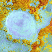
The hematite-rich deposit sprawls across Meridiani in a curving swath about 500 kilometers (300 miles) wide by 300 km (200 mi) high. It has an irregular outline, with a few "hot spots" where topography has concentrated the deposit - or slowed its erosion. One such is this roughly circular patch, about 25 km (15 mi) in diameter.
The TES instrument found hematite makes up 15 to 20 percent of the surface in this feature. Geologists think it is most likely an old crater, full of hematite-bearing sediments. But the crater's rim has long since worn away, and how deep the stack of sediments goes remains unknown.
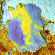
Mesa
About 80 km (50 miles) north of the old crater stands a mesa that offers a look at layers both above and below the hematite layer. Its outline much eroded, the mesa measures roughly 30 km (20 miles) in diameter and it stands about 300 meters (1,000 feet) above the ground to the east.
Laser altimeter profiles across the mesa show that its upper surface has a trough running north-south; this appears in yellow in the image. The east and west sides rise 20 to 30 meters (65 to 100 feet) higher. Blue tints on the mesa's east and west indicate a dustier surface, while the yellow in the trough shows the hematite area has larger particles.
TES data from orbit indicate the hematite is richest in the trough, while the higher sides of the mesa are comparatively hematite-free. TES observations also show little or no hematite on the eroded surfaces surrounding the mesa, either the dissected terrain to the north and east (light blue) or the etched terrain (reddish tints) to the south and west.
Thus it appears the hematite-bearing layer is sandwiched between two others that contain little or none of it. To a geologist, this indicates the period that saw the hematite form was a comparatively brief episode.
Erosion
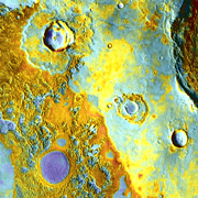
The surface of Meridiani is old, though not as old as the more heavily cratered regions south and east of it. As geologists survey the scene, they see abundant evidence for erosion affecting the landscape over a long time.
Aprons of ejected rocks and debris surround the small craters seen here. These partly protected the underlying ground from erosion, providing a kind of rocky armor.
The blue-tinted circular structure is likely an even older crater that became filled with sediments. It is 8 km (5 miles) in diameter and 115 meters (380 feet) high. Erosion has now removed the crater's rim, plus ejecta that surrounded it.
What's left is a hardened pile of sediments, with a broad, 5 meter (16 feet) deep depression in the middle. TES data show its eastern side contains a small percentage of hematite. Its blue color suggests it is topped with a layer of loose, fine-grain debris.