In the Groove: Mawrth Vallis
Of all the channels carved by flowing water on Mars, one of the more unusual is Mawrth Vallis, whose name comes from the Welsh word for Mars. Mawrth winds through northwest Arabia Terra for some 640 kilometers (400 miles) before emptying into Acidalia Planitia on the edge of the vast northern lowlands.
Unlike many outflow channels that start in regions of chaotic terrain, Mawrth just appears and then grows deeper as it heads downstream, holding a width of approximately 15 km (9 mi) until it widens near its mouth.
Second - and this gives the valley its scientific interest - along its course lie exposures of weathered clay minerals called phyllosilicates. These are evidence for extensive water activity early in Martian history, a time when researchers think life had its best chance to start on Mars.
For this reason, scientists are considering Mawrth as a possible landing site for NASA's next rover spacecraft, the Mars Science Laboratory, or MSL for short. Scheduled for launch in 2009, MSL will have the task of analyzing soil and rock samples for organic compounds. Wherever it is finally sent, the rolling robot geologist will be looking for environmental conditions that could have supported microbial life.
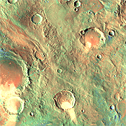
This false-color view shows the entire length of Mawrth Vallis as it weaves a path down out of the ancient cratered highlands toward its valley mouth at upper left. The view is a mosaic assembled from infrared images taken during daytime and nighttime by the Thermal Emission Imaging System (THEMIS) on NASA's Mars Odyssey orbiter.
THEMIS is a camera that images Mars at 5 visible wavelengths and 10 infrared ones. Combining Sun-warmed daytime views with those taken late at night gives scientists clues to the nature of the surface materials. In simple terms, massive materials such as rock outcrops and hard sediments don't become as cold at night as do fine-grain materials such as sand and dust, which give up heat more easily.
In this false-color image researchers have tinted sand, dust, and fine-grain sediments in shades of blue and green (bluer means finer grains), while harder materials, gravel, and rocks appear in tints of yellow, orange, and, in a few places, red.
In the Beginning
Mawrth's enigma begins with its lack of an obvious source. Most outflow channels on Mars start in an area of what scientists call chaotic terrain. The term is apt.
Chaotic terrain describes the confused jumble of hills and mesas that are left standing when subsurface water, triggered perhaps by volcanic or faulting activity, bursts from the ground. The water, escaping through faults and cracks, undermines the surface (which collapses) and then surges downslope in a catastrophic flood that quickly erodes a channel. Left behind is a ruined landscape deserving of the name chaos.
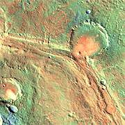
Mawrth, however, has no such feature marking the head of its channel. In fact, it's hard to pinpoint exactly where the channel begins. In the northwest (upper left) part of this small image, a distinct channel exists, but as you trace it into higher elevations toward the southeast, its course becomes steadily less visible.
At bottom center is a crater 25 km (16 mi) wide. A broad depression lies on its northern and eastern sides, with an elevation 500 meters (1600 feet) higher than the channel. Nonetheless, this low area shows little or no sign that water flowed through it or originated here.
So where did Mawrth's waters come from? Scientists have no clear-cut answer.
On the Terrace
Midway along its path, Mawrth bends westward at an old, smooth-floored crater some 38 km (24 mi) wide. The crater predates Mawrth, although by how long is unknown. Its floor, which is 100 to 200 m (330 to 660 ft) lower than the channel, has been filled in part by sediments washed in from the valley. This suggests that during part of its history, the crater held a lake.
The channel bed itself shows ridges and terraces that indicate floodwaters poured down the valley on at least two occasions, perhaps more. The episodes of flooding might have come just hours apart - or millions of years may have separated them.
The northern side of the channel has a few small gullies that run straight down the slope. These are 50 to 100 m (160 to 330 ft) deep and may line up with a few geologic faults that cut across the valley at right angles to it. The gullies indicate yet another stage of erosion; if fault-related, they could have been eroded by groundwater seepage.
Landing Strip
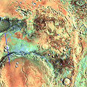
Farther downstream, Mawrth's channel narrows, then turns northward and makes a wide bend around a highland area next to a large, ancient crater. The crater, seen in part at lower left in the small image, spans about 90 by 105 km (55 by 65 mi).
Data from the OMEGA instrument on the European Space Agency's Mars Express orbiter revealed the highland area contains exposures of weathered clay minerals. These deposits attracted high scientific interest because nature needs lots of water to make the minerals. In the small image, the clays appear for the most part in the reddish-brown areas.
Scientists studying the area noted that from a geological perspective, the "clay-making episode" was neither the oldest nor the most recent event. Instead, the clay layers lie sandwiched roughly in the middle of the sediments, indicating that here at least, the wet episode had a distinct beginning and an end.
The existence of clays, however long the wet period lasted, hold great interest for science. On Earth, clay minerals easily preserve microscopic traces of life's activity, and the same is reasonable to expect on Mars if the planet had a biosphere when the clays formed.
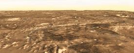
Scientists have not yet decided where to land NASA's next Mars rover, MSL, the Mars Science Laboratory. One of the 36 potential sites under consideration, however, lies in the highlands on the northern edge of the large crater. There's a closer view of the potential landing site here.
MSL will be able to roam much farther than the Mars Exploration Rovers Spirit and Opportunity. MSL's minimum range is 20 km (12 mi), and if all goes well it should easily exceed that. If this site is chosen, MSL would land in the relatively smooth area that looks bluish-green, then drive to the nearest outcrop of the clay, and set to work.
Mawrth Vallis