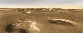
Cydonia: Martian Mystery Region
Cydonia Mensae lies in Mars' northern hemisphere, on the ragged boundary between the cratered highlands of western Arabia Terra and the sprawling, flat northern lowlands of Acidalia. A geological transition zone, Cydonia includes eroded mesas, impact craters, and generally smooth ground separating them. The famous "Face" is one of those eroding mesas.
Two scientific stories unfold here. One story concerns the difference in elevation between the highlands and lowlands, amounting to 1 kilometer (half a mile) in most places. What caused this sharp dichotomy in the crust? Despite years of debate, no one knows for sure.
The other story - spurred by data from the Mars Global Surveyor and Mars Odyssey missions - centers on the presence of water (or ice) in the ground, revealed by spacecraft instruments. Scientists want to know how the water got there and what role it has played in shaping the landscape. Frozen-ground features seen in Earth's polar regions can be found here and elsewhere on Mars, hinting that similar processes are at work.
And like Earth, Mars also undergoes ice ages. These climatic changes unroll over thousands of years, driven by slow periodic shifts in the Martian orbit and the tilt of the planet's axis. The result was to cover the ground in middle and even equatorial latitudes with deposits that mingle dust with snow and ice.
The equatorial regions have since dried out to depths of hundreds of meters (yards) or more, but the middle latitudes, including places such as Cydonia, may have water-ice-rich ground only a few meters down. Water's presence has implications for the chances of possible life - and it might even be of direct use to future human explorers.
This Cydonia image combines numerous frames taken at visible wavelengths by the Thermal Emission Imaging System (THEMIS), a camera on NASA's Mars Odyssey orbiter. THEMIS views Mars at 5 visible and 10 infrared wavelengths; its multi-band picture of the Red Planet gives scientists clues about the surface materials, and its wide-field yet sharp views put geological features into context.

Old and New
These two craters look markedly different and, between them, both offer hints at changes in the Martian climate. The crater at top is noticeably larger, 9 km (5.6 mi) wide, compared to the lower crater's 5.2 km (3.2 mi). And depth measurements find the lower crater is about 1,000 meters (3,300 feet) deep, some three times deeper than the larger crater.
The size of a crater depends on impact velocity, but even more on the size of the meteorite. And as a general rule of thumb, bigger meteorites tend to meet their fates earlier in solar system history rather than later. But these two craters come close enough in size to make the general rule risky to apply here.
Instead, what really sets these two craters apart is how fresh they appear - or how old, in the case of the larger one. The smaller crater is a smooth-sided bowl with a sharp rim and a relatively deep interior. The larger crater is much shallower, its flat interior looks like smooth debris fills it almost completely, and the rim's edge appears soft and rounded.
The small crater might have formed last week or last century, while the larger one has a much greater age. (By how many years is a question no geologist can answer as yet.)
Between these two craters, and throughout their vicinity, the ground shows meandering, braided patterns that suggest flow. This ground is some of the mantling material that scientists suspect contains ice at shallow depths. The debris covers most of the surface - and it left deposits over the big crater's interior.
But not the smaller crater's: no soft mantle lies across it. Whenever this crater formed, the latest episode of Martian climate change has left no marks on it. The most reasonable explanation is that the crater formed since Mars' last ice age, which ended very approximately 400,000 years ago.

Trickling Away
Signs of flow are prominent across many parts of Cydonia, including these narrow channels, which lie on the northern side of a relatively fresh crater. The crater is 8.6 km (5.3 mi) wide and about 900 meters (3,000 feet) deep.
From its appearance, the crater is not quite as fresh as the smaller crater mentioned in the previous section - but it is far from being as debris-filled as larger one. Thus it is likely closer in age to the smaller one.
Gullies furrow the upper parts of the crater's interior, showing where slides of debris have widened the rim a little and kept it looking sharp-edged. These slides may have been helped along by flows of groundwater or melting snow coming out of the rock just below the rim level.
The ground lying north of the crater is not as flat as it appears. In fact, from the crater rim the terrain rises some 60 meters (200 feet) to reach a broad ridge about halfway up the image. This ridge is imperceptible in the photo, but revealed by laser altimeter measurements. This means that much of the flow we see here went downhill toward the crater.
When an ice-rich mantle of material starts to melt, the water escapes, either into the air by flowing downhill. As this happens, scientists conclude, the mantle will collapse as the supporting ice goes away. The result will be a smooth landscape cut by thin channels. If all the ice were removed, the mantle would collapse totally, and much of it might blow away as dust.

Water In the Basement
The scientific evidence for water underlying the surface of Cydonia comes from the neutron and gamma-ray spectrometers on the Mars Odyssey spacecraft. These found strong evidence of hydrogen in the ground throughout this entire part of Mars. As a gas, hydrogen would soon leak away, but in the form of water-ice it could linger.
Second, many landscape features, such as the rounded ring of ejected debris around this crater, suggest water-saturated ground. Geologists think this kind of ejecta apron, called a pedestal crater, forms where the ejected debris from the meteorite impact covers ice-rich ground with a rocky layer that is relatively durable.
As climate change erodes the ice-rich ground, the portion that lies under the ejecta remains intact. Over time, the crater ends up on its pedestal because the surrounding surface has lowered. An identical ring appears in Utopia and other locations where the evidence for ground ice is just as strong.
Elsewhere in Cydonia and in geographically similar Deuteronilus Mensae, debris at the foot of isolated mesas appears to have flowed down from them. Even the flat ground between mesas shows flow-features in many places.

A Warm Face
Among the scattered mesas in Cydonia is a famous one whose appearance earned it the nickname "The Face." Despite fanciful theories, the mesa is simply a hill about 300 m (1,000 feet) high. Other mesas nearby have generally similar shapes.
High-resolution images of The Face, however, reveal its northern and eastern sides have a smooth covering material. Where it occurs on slopes, scientists have dubbed it "pasted-on terrain" because that's just what it looks like. The material likely has the same origin as the mantles of dust-covered snow and ice seen elsewhere.
The pasted-on material lies on the sides of The Face that point away from the greatest solar heating, much like the snow that survives into summer lies on the poleward-facing slopes of mountains on Earth. Thus the material may still contain water (as snow or ice) just below the surface. On the warmer sides of this and other mesas, however, the material has eroded away.
The flat ground around the mesas shows several small impact craters. There are also a number of features that look like cones with dimples in the top. (See at the foot of the other mesa in the picture.) These might be what geologists call "rootless cones" - basically, places where volcanic heat met subsurface water and the resulting steam blasted through the surface, creating a cone.
Yet other signs of volcanism - obvious lava flows, for example - are rare in Cydonia, so scientists think a more likely explanation is a pingo. Pingoes are found commonly on Earth in polar regions. Essentially, a pingo is a gigantic frost heave or a kind of ice-blister. This would fit in with the spacecraft observations of a water-rich ground.
Cydonia's Famous "Mystery" Mesa